- BY Kevin Barry BSc(Hons) MRICS
- POSTED IN Latest News
- WITH 0 COMMENTS
- PERMALINK
- STANDARD POST TYPE
Kircubbin Pier: A Village Waiting for Its Moment
Published: Strangford Lough Crossing Campaign | www.strangfordloughcrossing.org
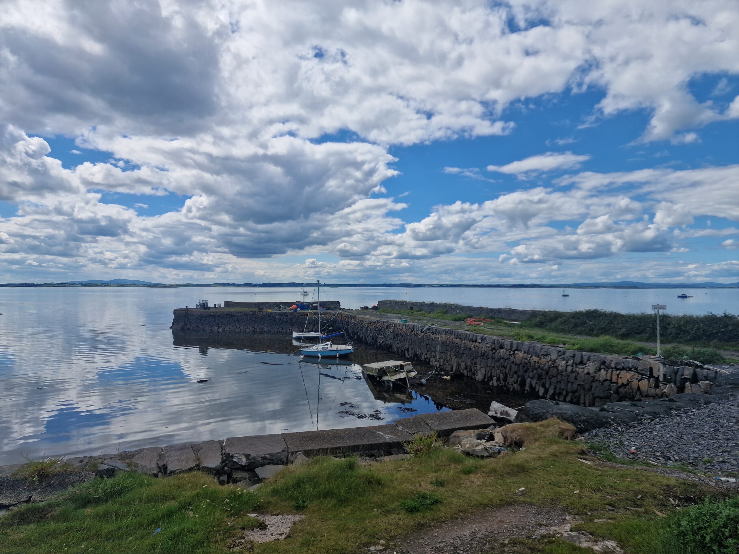
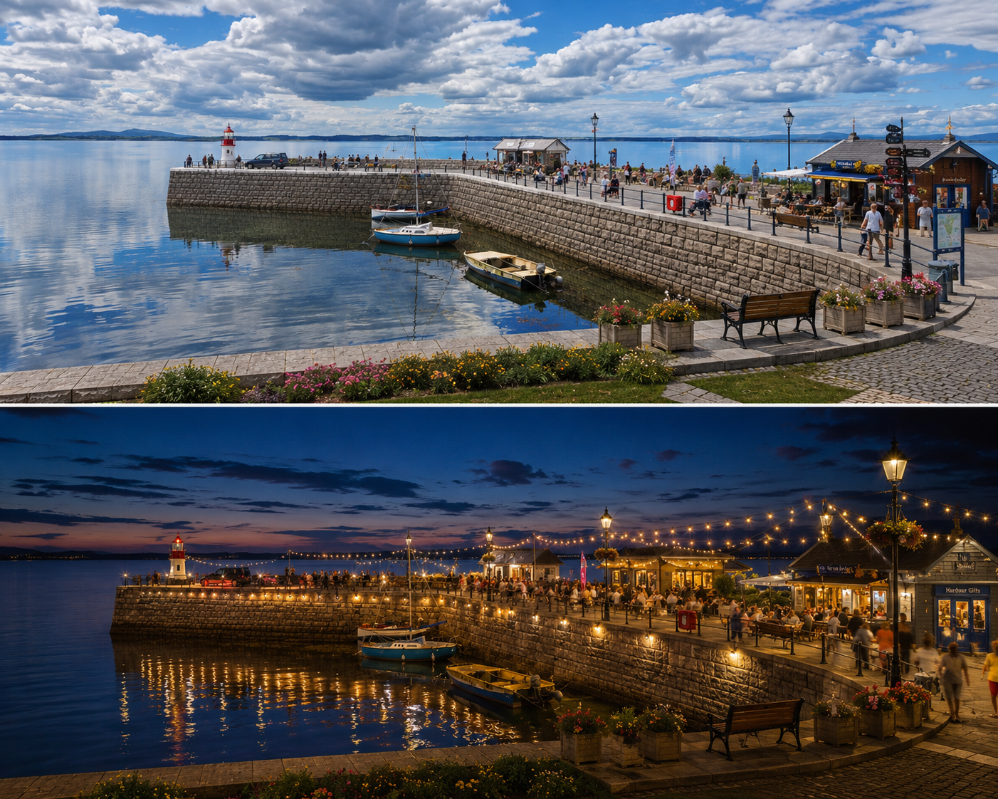
Look at the photographs above. The first photo shows Kircubbin pier today. Beautiful in its own right, set against the extraordinary backdrop of Strangford Lough, with the Mournes visible on the horizon on a clear day — but undeniably quiet, its stonework ageing, its potential unrealised.
The second split photo shows a vibrant, thriving harbour during daytime: at night, warm lights, outdoor dining, visitors, commerce — a waterfront alive with economic activity.
The question this campaign asks is simple: which of those two futures belongs to Kircubbin?
The Historical Record
Kircubbin is a village with deep roots on the western shore of the Ards Peninsula, sitting on the A20 Portaferry Road. Its pier and harbour have served local fishing, small-scale trade and recreational sailing for generations. The village sits at the approximate mid-point of the peninsula, roughly equidistant between Newtownards to the north and Portaferry to the south.
It is a location of genuine natural beauty. It is also, as the Assembly record has recently made plain, a location experiencing serious infrastructure stress.
What the Assembly Record Shows
On 3 February 2026, the Northern Ireland Assembly debated the impact of storms on the A20 Portaferry Road in an Adjournment session raised by Kellie Armstrong MLA (Hansard, Volume 188, No. 2). The documented record is instructive.
Matthew O’Toole MLA, speaking in that debate, stated on the formal record: “All the way down the Ards peninsula, at the southern tip, there is reliance, as Mike Nesbitt said, on the A20 to get to school, work, daily activities and other vital appointments…the storm disruption that disrupts the A20 might often disrupt the ferry crossing from Portaferry to Strangford, which puts even more emphasis on planning, preparing and building in resilience for the residents of areas along the A20 from Portaferry up to Kircubbin, Greyabbey and all the way to Newtownards.”
On Kircubbin specifically, the same debate produced this observation, recorded in Hansard: “You have only to drive through Kircubbin to see the fragility of the sea wall there and how vulnerable it is. You do not need to be an expert on coastal erosion, storms or retaining walls, or to be an engineer, to see quite how fragile things are when you drive through Kircubbin.”
Michelle McIlveen MLA, also speaking in that debate, stated directly: “A bridge would provide an alternative route off the peninsula that does not depend on a coast-hugging road that is vulnerable to storm surge. It would improve traffic flow for local residents, visitors and emergency services. There is little doubt that a bridge would boost tourism and local commerce by making lower Ards and the rest of the peninsula more accessible all year round.”
These are on-the-record statements by elected representatives in the Northern Ireland Assembly, not campaign assertions. They are retrievable at Hansard, Volume 188, No. 2, 3 February 2026.
The Economic Baseline
The NI Executive’s Sub-Regional Economic Plan Technical Annex (October 2024) documents the economic position of Ards and North Down Borough Council with precision. It records that median gross weekly wages in Ards and North Down stand at £450.10 — the lowest of all eleven council areas in Northern Ireland, and significantly below the NI average of £528.90. The area has the second lowest rate of business research and development intensity in Northern Ireland, at 0.5%, against a NI average of 1.5%. Export intensity stands at 13%, against a NI average of 17%.
These are not abstract statistics. They describe a community whose economic potential is, by the documented evidence, constrained by connectivity rather than by its people. The same Technical Annex records that Ards and North Down had the highest rate of early-stage entrepreneurial activity in Northern Ireland in 2021-2023, at 13% against a regional average of 9.2%, and the third highest rate of tertiary educational attainment at 44.8%. The talent is present. The infrastructure is the limiting factor.
The Cleddau Comparison
The Strangford Lough Crossing Campaign’s analysis — published at www.strangfordloughcrossing.org — draws on the documented experience of the Cleddau Bridge in Pembrokeshire, Wales, opened in 1975, the same year the MV Portaferry arrived at Strangford from the Cleddau crossing. That is not a rhetorical flourish; it is a documented fact of the vessel’s operational history.
In its first year of operation, the Cleddau Bridge recorded 885,900 crossings. By 2024, annual crossings had reached 4,745,000 — a 20-fold increase over the ferry it replaced. The Strangford Ferry, over the same period, averages approximately 237,250 crossings annually, a figure which has remained effectively static.
A commercial operator looking at those two trajectories would reach an obvious conclusion. The Strangford crossing has been operating a constrained, capped-capacity system for almost fifty years. The demand — suppressed by operating hours, weather disruptions, and capacity limits — has not disappeared. It is waiting.
What a Fixed Crossing Would Mean for Kircubbin and the Peninsula
It would be improper to make specific regeneration claims without a completed feasibility study. That is precisely what this campaign is calling for: an independent, TAG-compliant feasibility study, estimated by specialist industry, to cost between £250,000 and £500,000. That study does not presume the outcome. It tests it.
What the documented evidence does establish is the direction of travel. The HITRANS Corran Narrows Fixed Link Feasibility Study, produced by Stantec UK and COWI in 2020, found that the introduction of a fixed link generates immediate and swift demand response: a combination of people already travelling making more journeys, induced journeys from tourism, and substitution effects from alternative routes. It found no environmental showstopper for the Corran Narrows.
A Strangford Lough Crossing would bring through-traffic past Kircubbin from the north — visitors accessing Portaferry and the crossing, residents travelling with a reliable alternative to the coastal road, and tourists exploring the full Ards and Lecale circuit rather than treating the peninsula as a dead end. A dead end does not sustain a harbour economy. A through-route does.
The Council’s own Integrated Strategy for Tourism, Regeneration and Economic Development 2018-2023 set a target of increasing overnight visitor spend from £46 million in 2016 to £82 million by 2030, and increasing the overnight trips market share from 6% to 10%. Connectivity is listed among the conditions for achieving those targets. The unrealiable ferry puts many possible visitors off, from cost and time viewpoint.
The A20 Itself: The Compounding Argument
The Assembly record of 3 February 2026 adds a dimension that is sometimes overlooked. The A20 Portaferry Road is not simply an inconvenient diversion route. It is, as the Hansard record reflects, a road whose foundations are “threatened by relentless coastal forces.” Mike Nesbitt MLA observed in that debate that “if engineers were looking at the road now, they would probably not build it in that location.” The coastal erosion policy against which all of this is measured dates, as stated on the Assembly record, to 1967.
The cost of continuing reactive maintenance on an inherently vulnerable coastal route, year after year, through an era of increasing storm frequency, is a cost that has not been formally set against the cost of an alternative. A Green Book-compliant 30-year net present value comparison of the ferry subsidy liability — documented at £2,090,000 net per annum in FOI DFI-2024-0366 — against a tolled crossing has not been commissioned by the Department. That comparison, alongside the A20 maintenance trajectory, forms a core element of the feasibility case.
A Village in the Frame
Kircubbin pier, as the photograph shows, is structurally intact and set in a location of exceptional natural quality. The pier exists. The lough exists. The village exists. What is missing is the traffic, the footfall, and the economic gravity that a fixed crossing would draw down the peninsula.
This campaign makes no promise about Kircubbin’s future. What it says, with documentary evidence, is that the future currently being offered — declining road infrastructure, a capped ferry service, the lowest wages in Northern Ireland, and a coastal erosion policy from the age of the Adler typewriter — is not the only available option.
For further information, the campaign’s full evidence base, including the Quintin QS TAG Appraisal (March 2026), the interactive feasibility dashboard, and the DfI traffic data visualisation, is available at www.strangfordloughcrossing.org.
The study costs between £250,000 and £500,000. That is, on the documented figures, between six weeks and two and a half months of the current annual ferry subsidy. It is a reasonable ask.
Kevin Barry BSc(Hons) MRICS, Chartered Quantity Surveyor Campaign Lead, Strangford Lough Crossing Campaign Portaferry, Co. Down; mail@kevinbarryqs.com | www.strangfordloughcrossing.org