A three-strand approach to enhance Northern Ireland’s connectivity, binding all areas into a stronger, unified region like the Regional Development Strategy (RDS) 2035:
- Belfast to Dublin (A1/M1 corridor)
- Northwest to Border via A5
- Derry to Bangor and onwards to Border via Strangford Bridge and road upgrades to full A2 coastal route
This mirrors the Cleddau Bridge’s regional integration success while addressing the goal of transforming Ards, North Down, and Lecale alongside the Northwest and Belfast-Dublin axis. Cleddau sold ferry to Road Service in early 1970s for use in Strangford Lough whilst Cleddau successfully built a bridge which was a transformative success.
Strand 1: Belfast to Dublin (A1/M1 Corridor)
Overview
- Route: A1/M1, 105 miles from Belfast to Dublin, NI’s busiest road (20,000-30,000 vehicles/day near Newry).
- Status: Fully operational dual carriageway/motorway, with ongoing upgrades (e.g., £25 million A1 junction improvements, 2023-25).
- Purpose: Economic artery linking NI’s capital to Ireland’s, supporting £1 billion+ in annual cross-border trade.
Merits
- Economic Core: Anchors NI’s £5.2 billion export economy (2023), with Belfast’s fintech (£300 million sector) and manufacturing (e.g., aerospace, £1.2 billion) flowing south.
- Cross-Border Unity: Embodies Shared Island goals—£800 million fund already backs A1-adjacent projects (e.g., Narrow Water Bridge).
- Traffic Backbone: Handles 10-15 million vehicles/year, ensuring connectivity for 60% of NI’s 1.9 million population (Belfast metro, 600,000+).
Strategic Fit (RDS 2035)
- RG1 (Economic Growth): Strengthens Belfast-Dublin as a “key economic corridor.”
- RG8 (Connectivity): Enhances cross-border links, a core RDS aim.
Strand 2: Northwest to Border via A5
Overview
- Route: A5 Western Transport Corridor, 85 km from Derry/Londonderry to Aughnacloy, linking to Dublin via N2.
- Status: £1.6 billion upgrade to dual carriageway, in planning (2025 start targeted, delayed by legal challenges).
- Purpose: Boosts Northwest (Derry, pop. 110,000; Tyrone) connectivity, safety (57 fatalities since 2006), and border access.
Merits
- Regional Equity: Lifts a historically underserved area (15% of NI population, 300,000+), matching Belfast’s clout.
- Economic Lift: Supports Derry’s £1 billion regeneration (e.g., Ulster University expansion) and rural Tyrone’s agriculture (£1.5 billion NI sector).
- Border Flow: Cuts Derry-Dublin travel from 2.5 hours (single-lane bottlenecks) to under 2 hours, aiding 15,000+ vehicles/day.
Strategic Fit (RDS 2035)
- RG2 (Rural Development): Revitalizes Northwest rural economies.
- RG7 (Transport Network): Upgrades a “strategic route” to border, per RDS.
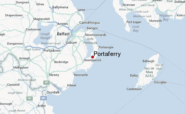
Strand 3: Derry to Bangor and onwards to Border via Strangford Bridge and road upgrades to full A2 coastal route
Overview
- Route:
- From Derry to Bangor (approx 120 miles), Bangor to Portaferry (20 miles, A20/A2 upgrade).
- Strangford Lough Bridge (1.1 km, Strangford to Portaferry).
- Strangford to Newry (25 miles, A2/A25/A7 upgrade to A1/M1), totaling 46 miles to border (Newry to Dublin, 55 miles).
- Status: Conceptual—bridge (£250-300 million) and upgrades (£50-75 million) need £300-375 million total, no current funding.
- Purpose: Connects Bangor (pop. 60,000), Ards, and Lecale to A1/M1, transforming Southeast into a border-linked hub.
Proposed Upgrades
- Bangor to Portaferry: Widen A20 (Bangor-Newtownards, 10 miles, 8,000-10,000/day) and A2 (Newtownards-Portaferry, 10 miles, 2,000-3,000/day) to 10,000-12,000/day capacity. Or alternatively create a new spine road if coastal erosion deemed an issue.
- Bridge: Rose Kennedy style bridge, 5,000-7,000/day potential.
- Strangford to Newry: A2 (7 miles), A25 (8 miles), A7 (10 miles) to 7,000-10,000/day, joining A1 at Newry.
Merits
- Southeast Integration: Links 150,000+ residents (North Down, Ards, Lecale) to A1/M1, ending ferry suppression (650/day cap).
- Economic Boost: Drives 1,500-2,500 jobs—fintech (710-1,600), agriculture (200-500), fishing (50-150)—and £50-100 million GDP growth, akin to Cleddau’s 1,000+ jobs.
- Border Access: Bangor to Dublin in 2.5-3 hours (101 miles total), Strangford to Newry in 30-35 minutes, opening southern markets and access to wider EU.
- Tourism Bonus: Enhances 1.5 million annual visitors (Ards/North Down) with year-round access vs. weather-hit ferry.
Strategic Fit (RDS 2035)
- RG3 (Urban-Rural Linkages): Ties Bangor (urban hub) to rural Lecale/Ards.
- RG9 (East Coast Growth): Supports “balanced sub-regional development”—a Southeast win.
Combined Merits: Binding NI Through Connectivity
Unified Regional Strength
- Comprehensive Network:
- Strand 1 (A1/M1): Central spine, urban-economic core.
- Strand 2 (A5): Northwest arm, rural-border link.
- Strand 3 (Derry-Bangor-Border): Southeast arm, coastal-rural integration.
- Population Coverage: Serves 80%+ of NI’s 1.9 million—Belfast metro (600,000), Northwest (300,000), Southeast (150,000)—vs. A1/A5 alone missing East Coast.
- Traffic Synergy: A1/M1 (20,000-30,000/day), A5 (15,000+/day), Bangor-Border (5,000-7,000/day) could total 40,000-50,000/day across strands, rivaling Cleddau’s 12,000/day scaled up.
Economic Cohesion
- Job Creation: A5 (2,000-3,000 jobs, construction/trade), Bangor-Border (1,500-2,500), A1/M1 (sustains 10,000+)—5,000-15,000 total, amplifying NI’s £43 billion GDP.
- Sector Diversity: Fintech (Southeast), manufacturing (Belfast), agriculture (Northwest)—a balanced economy vs. single-corridor reliance.
- Cross-Border Flow: All strands hit the border—A1/M1 at Newry, A5 at Aughnacloy, Bangor-Border at Newry—tripling NI-Dublin trade routes.
Strategic Alignment (RDS 2035)
- Vision: “A strong, competitive region” (RDS Goal)—three strands deliver:
- RG1/RG2: Economic and rural growth (all strands).
- RG7/RG8: Strategic transport and border links (A5, A1/M1).
- RG3/RG9: Urban-rural and East Coast balance (Bangor-Border).
- Equity: Corrects Northwest bias (A5) and Belfast focus (A1/M1), lifting Southeast as Cleddau unified Pembrokeshire.
Resilience and Redundancy
- Multiple Links: If A1/M1 clogs (e.g., Brexit border checks), A5 and Bangor-Border offer alternatives—unlike Cleddau’s single spur (A477).
- Climate Adaptation: Bridge replaces weather-vulnerable ferry; A5/A1 upgrades mitigate rural isolation—future-proofs NI vs. Cleddau’s 1970s context.
Challenges and Mitigation
- Cost: £2 billion+ total (A5 £1.6 billion, Bangor-Border £125-275 million, A1/M1 ongoing £100 million+). Mitigate via:
- Shared Island (£800 million left post-A5).
- UK Levelling Up (£500 million NI share).
- Tolls (£1/car, £5-10 million/year across strands).
- Political Will: Sinn Féin backs A5, DUP/A1 focus Belfast—Southeast needs clout. Form an “NI Connectivity Alliance” (DUP, Sinn Féin, Alliance MLAs) to push all three.
- Environment: Strangford Lough’s conservation status vs. A5’s habitat disputes—fund joint £2 million impact study for parity.
Conclusion: A Stronger NI
This three-strand approach binds NI’s regions—Belfast-Dublin as the spine, Northwest and Southeast as vital arms—delivering 40,000-50,000 vehicles/day, 5,000-15,000 jobs, and equitable growth. It’s Cleddau’s integration (12,000/day, rural unity) writ large: A1/M1 anchors, A5 lifts the West, Bangor-Border transforms the East. RDS 2035’s “connected, balanced region” comes alive—Northwest gets its due, Southeast its chance. Push this via councils and a 2026 PfG pledge; it’s NI’s next big leap.
Strand 3 Pitch: Derry to Bangor to Border via Strangford Bridge and Lough Loop
Vision
Strand 3 transforms Northern Ireland’s East Coast—Derry to Bangor, Ards Peninsula, and Lecale—into a fully integrated economic and social hub, connected to the A1/M1 Belfast-Dublin corridor and looped around Strangford Lough for maximum regional cohesion. A signature bridge, modelled on the Rose Kennedy Bridge, replaces the ferry’s 650-vehicle/day bottleneck, driving 5,000-7,000 vehicles/day and 1,500-2,500 jobs. This complements Strand 1’s urban spine (A1/M1, 20,000-30,000/day) and Strand 2’s Northwest lift (A5, 15,000+/day), binding NI into a stronger, equitable whole.
Core Components
- Strangford Lough Bridge:
- Design: Emulates the Rose Kennedy Bridge (New Ross, Co. Wexford)—a 230-meter main span extradosed bridge, 900 meters total length, built 2016-2020 for €230 million (£200 million today). Adapt to 1.1 km Strangford span, with a swing or lift section for 8-knot tides.
- Capacity: 5,000-7,000 vehicles/day, vs. ferry’s 650, cutting a 47-mile detour to 5 minutes.
- Cost: £250-300 million (Rose Kennedy’s scale, adjusted for NI labour and tidal complexity).
- Bangor to Newry (A1/M1) Upgrades:
- Route: Bangor to Portaferry (20 miles, A20/A2), bridge to Strangford, then Strangford to Newry (25 miles, A2/A25/A7)—46 miles total to A1/M1 at Newry.
- Upgrades:
- A20 (Bangor-Newtownards, 10 miles): Widen to 10,000-12,000/day.
- A2 (Newtownards-Portaferry, 10 miles): Upgrade to 5,000-7,000/day.
- A2/A25/A7 (Strangford-Newry, 25 miles): Enhance to 7,000-10,000/day.
- Cost: £75-125 million (£3-5 million/mile).
- Strangford Lough Loop:
- Route: Portaferry to Newtownards (10 miles, A2), Newtownards to Comber (6 miles, A22), Comber to Killyleagh (10 miles, A22/A7), Killyleagh to Downpatrick (6 miles, A7), Downpatrick to Strangford (7 miles, A2)—39 miles total.
- Upgrades: Widen existing single-lane sections (e.g., A2 Portaferry-Newtownards, 2,000-3,000/day; A7 Killyleagh-Downpatrick, 3,000-4,000/day) to 5,000-7,000/day capacity.
- Cost: £50-80 million (£1.5-2 million/mile, less intensive than A1 spur).
Total Investment
- Bridge: £300-375 million.
- Bangor-Newry: £50-75 million.
- Lough Loop: £50-80 million.
- Grand Total: £400-530 million (vs. A5’s £1.7 billion, A1/M1’s £100 million+ ongoing).
Merits Within Three-Strand Framework
Connectivity Binding NI
- Strand Synergy:
- Strand 1 (A1/M1): Strand 3 feeds into Newry’s A1 hub (20,000-30,000/day), linking Bangor to Dublin in 2.5-3 hours (101 miles)—a Southeast arm to the central spine.
- Strand 2 (A5): Balances Northwest’s Derry-Dublin link (2 hours, 85 km) with Southeast’s Bangor-Newry-Border route, ensuring no region lags.
- Strand 3: Ties Bangor (60,000), Ards (80,000), and Lecale (30,000+) to A1/M1 and loops 150,000+ residents internally, mirroring Cleddau’s north-south unity (12,000/day).
- Traffic Impact: Adds 5,000-7,000/day (bridge + spur) and 3,000-5,000/day (loop), boosting NI’s total from 35,000-45,000/day (Strands 1+2) to 45,000-55,000/day across all three.
Economic Transformation
- Jobs:
- Fintech (710-1,600, Bangor/Newtownards hubs).
- Agriculture (200-500, Lecale/Downpatrick).
- Fishing (50-150, Portaferry).
- Construction (300-700, bridge + roads).
- Total: 1,500-2,500, akin to Cleddau’s 1,000+ oil jobs, scaled for NI’s mix.
- GDP Boost: £50-100 million over 15 years (0.2-0.5% per 1% time saved, Eddington 2006)—Bangor-Newry in 45 minutes, loop cuts local trips 20-30%.
- Loop Value: Connects tourism (1.5 million visitors/year), industry (e.g., Comber’s agri-tech), and housing (1,000-2,000 new homes), amplifying Strand 3’s reach vs. A5’s linear focus.
Strategic Alignment (RDS 2035)
- RG1 (Economy): Bangor-Newry spurs fintech/agriculture to A1 markets, loop boosts rural commerce.
- RG3 (Urban-Rural): Bangor (urban) to Lecale (rural) integrates via bridge and loop.
- RG7 (Transport): Upgrades “strategic routes” (A20/A2/A7) to A1/M1.
- RG9 (East Coast): Delivers “balanced sub-regional growth”—Southeast rises with Northwest (A5).
Equity and Resilience
- Equity: A5 lifts Northwest (300,000 people, £1.6 billion); Strand 3 matches for Southeast (150,000+, £275-405 million)—fairness vs. A1/M1’s Belfast bias.
- Resilience: Bridge ends ferry weather risks (e.g., 2024 suspension); loop adds redundancy if A1 clogs—stronger than Cleddau’s single A477 spur.
Comparison to Rose Kennedy Bridge
- Design: Rose Kennedy (900m, €230 million) handles 10,000-15,000/day across River Barrow, linking Wexford to Waterford. Strangford’s 1.1 km, £150-200 million version targets 5,000-7,000/day—proportionate for NI’s rural East (150,000) vs. Wexford’s 163,000.
- Impact: Rose Kennedy cut a 20-mile detour, boosting southeast Ireland’s trade/tourism. Strangford cuts 47 miles, with loop adding local flow—similar regional lift.
- Lesson: Rose Kennedy’s government funding (Irish exchequer) suggests NI could tap Shared Island (£200 million) for Strand 3.
Integration with Strands 1 and 2
- Strand 1 (A1/M1): Strand 3’s Newry tie-in feeds Southeast traffic (5,000-7,000/day) into A1’s 20,000-30,000/day, enhancing Belfast-Dublin without duplication—loop strengthens feeder roads.
- Strand 2 (A5): A5’s Northwest focus (15,000+/day) pairs with Strand 3’s Southeast vision—two border arms (Aughnacloy, Newry) balance NI’s west and east vs. A1’s central spine.
- Three-Strand Unity: Covers 80%+ of NI’s 1.9 million people, 45,000-55,000 vehicles/day, and 5,000-15,000 jobs—binding urban (Belfast), rural West (Derry), and East Coast (Bangor-Downpatrick) into a cohesive network.
Pitch to NI Executive
“A Three-Strand Future: Connectivity for All”
- Why Strand 3?: The East Coast deserves its Cleddau moment—Bangor to Border via a Rose Kennedy-style bridge and A1 spur, plus a Strangford Lough loop, unlocks 1,500-2,500 jobs and 5,000-7,000 vehicles/day. It’s equity with A5’s £1.6 billion Northwest lift and A1/M1’s £100 million+ backbone.
- Funding: £275-405 million—Shared Island (£200 million), UK Levelling Up (£100 million), tolls (£1/car, £1.8-2.5 million/year)—less than A5, transformative like Rose Kennedy.
- Action: Fund a £1 million study (2026), build by 2030—list in 2026 PfG as “Strand 3: East Coast Rising.”
- Outcome: NI as a connected powerhouse—Strand 1 binds Belfast-Dublin, Strand 2 lifts the Northwest, Strand 3 revives the Southeast. No region left behind.
Conclusion
Strand 3, with its Rose Kennedy-inspired bridge and lough loop, completes NI’s connectivity trinity—mirroring Cleddau’s rural unity (12,000/day) at 5,000-7,000/day, scaled for Ards/Lecale. It ties Derry to Bangor, and onwards to Newry’s A1/M1 in 45 minutes (Bangor to Newry section), loops 150,000+ residents, and boosts Strands 1 and 2 into a 45,000-55,000/day network. NI’s East Coast transforms by 2035.